Not The Subway, Not The Highway—Introducing The Landway!
This article was written by BCU Labs members Zachary Yaro and Anne Griepenburg
One of the most recognizable maps of Boston shows the T with each line a unique color.

Guess what year this is from!
Subway maps pack a lot of information into an iconic image that answers your top public transit questions: What line do I take? Where do I transfer? What is the stop before I need to get off the train? The actual city doesn’t look anything like the lines on a subway map but it is effective because it shows you the network.
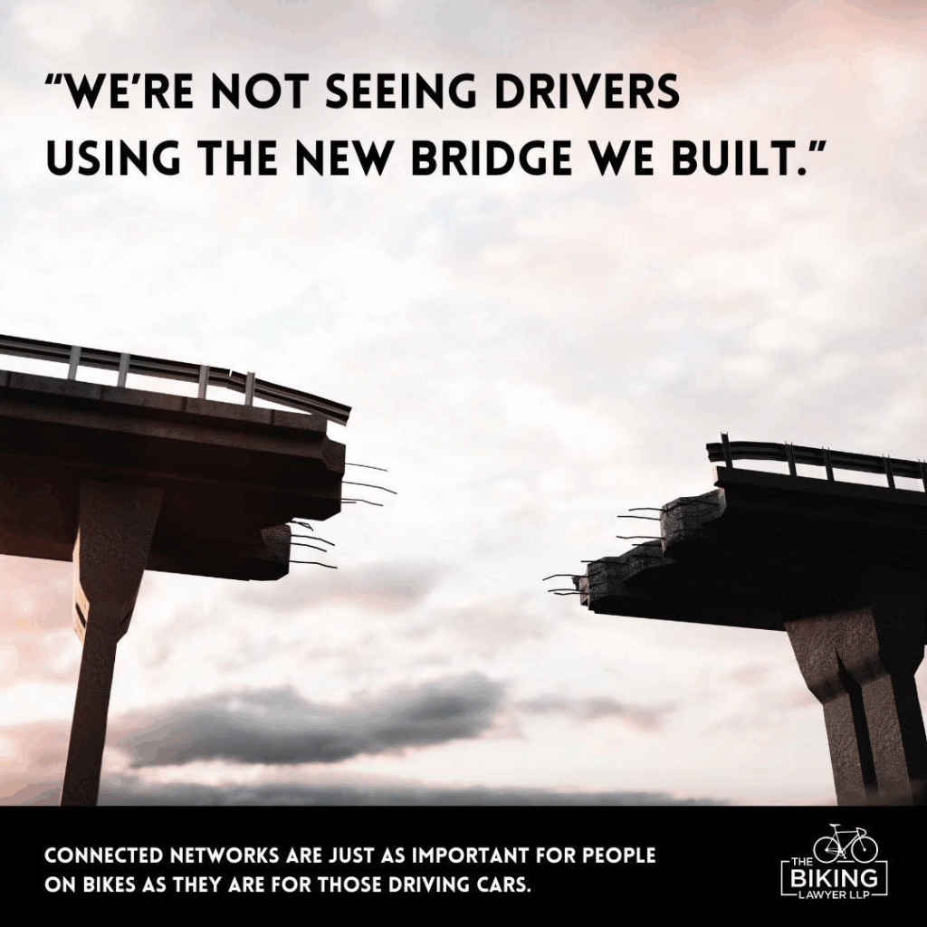
As travelers trying to navigate on bikes, scooters, mobility devices, and so on, we have similar questions. As our cities build out “micromobility” routes, we encounter the frustration of places where they don’t connect. Imagine the Red Line with no tracks between Central and Kendall—it would make it very hard to plan your trips between downtown and Harvard Square, and you might give up on the subway altogether!
It can be difficult to create a new reality if you can’t visualize it. Talking about the need for a local “bike network” doesn’t convey the pieces to build and the places to connect. In Tom Babin’s video about the Paris réseau vélopolitain, he discussed how people there tackled that challenge, and one approach they used was conveying the connections the network would provide in a format people were already familiar with: a subway map.
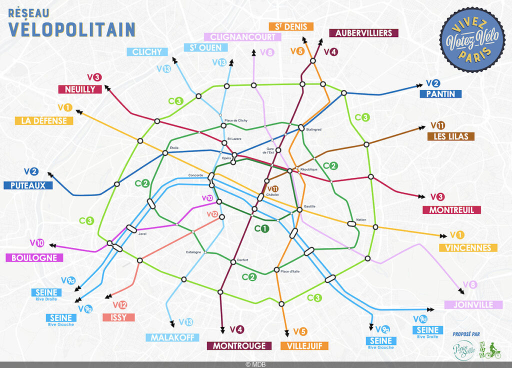
I was inspired to try the same thing here, starting in Cambridge and adding from there.
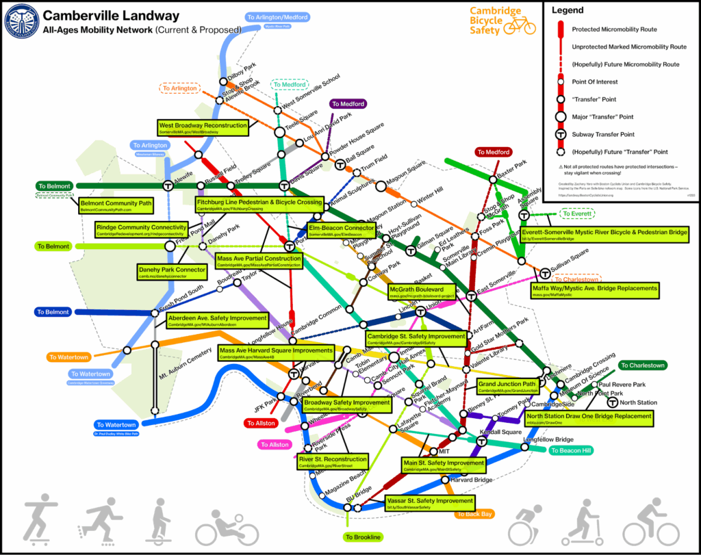
This is the current vision for the Cambridge + Somerville “Landway”—the network of off-street paths and separated micromobility lanes people of all ages and abilities can use, especially if they feel unsafe sharing street space with cars and trucks:
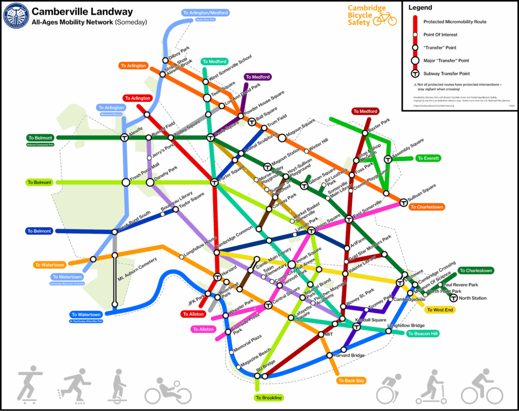
What this map isn’t
Like a subway map, this isn’t meant to be 100% geographically accurate or show every precise street-level detail. As a subway map doesn’t tell you station layouts, that abstracted, bird’s eye view doesn’t address precise design choices such as intersection design, which play massive roles in micromobility safety! What it does do is show how the broader network will enable cross-town connections between myriad noteworthy destinations for people of all ages and what missing pieces will get us there.
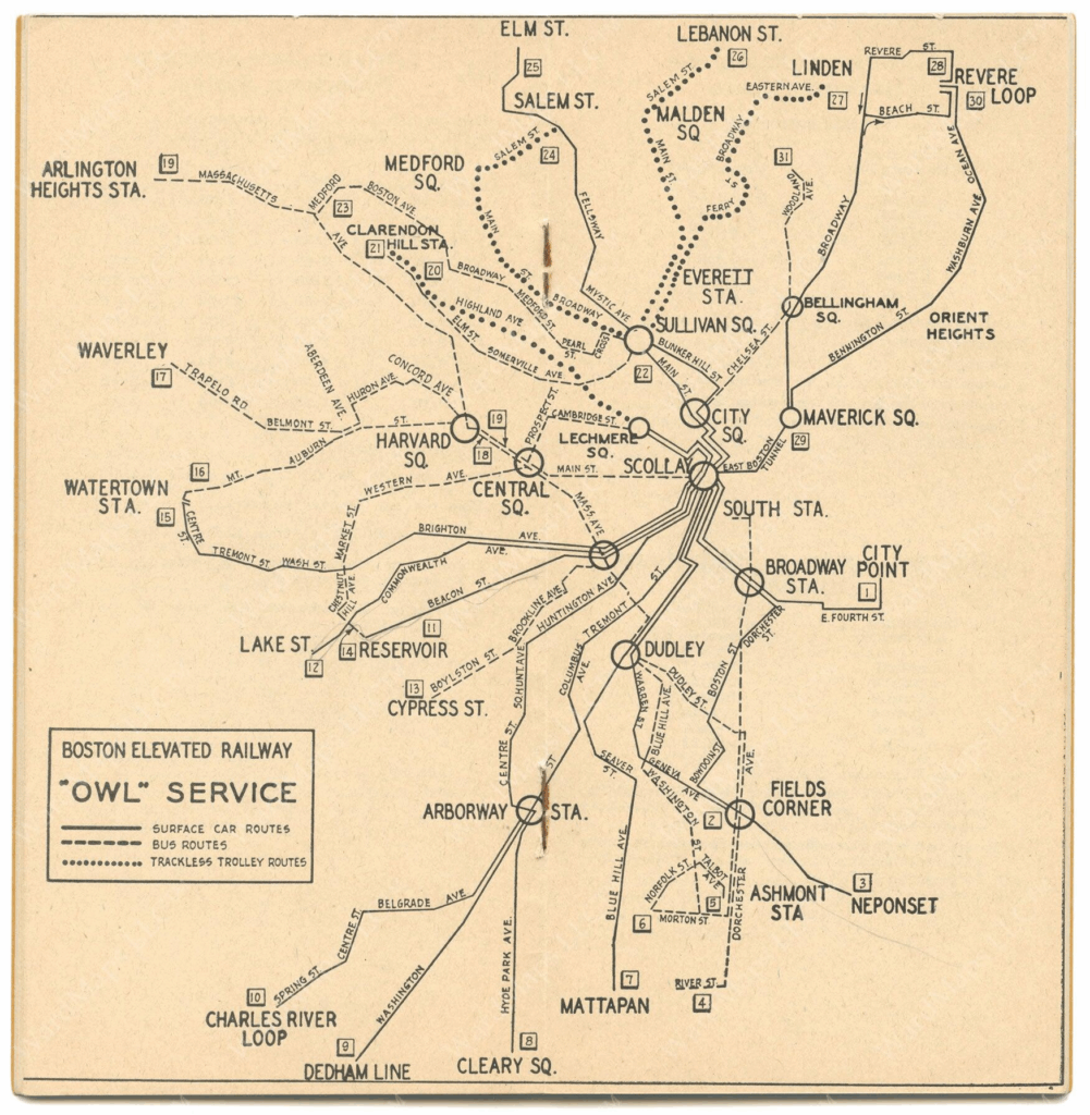
Before the T map we know today, more precise maps were also more complicated
Where are we now?
Obviously the network is currently far from complete. This is what we have at time of writing:
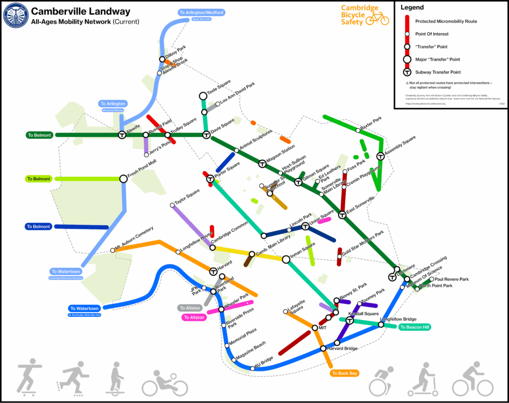
Many people ask why the increase in people choosing to bike instead of drive isn’t increasing even faster than it already is. When you see the lack of interconnectivity between neighborhoods—especially the lack of north-south connections—it becomes more apparent how the existing fragments of lines don’t quite get people to their destinations.
Destination in sight
Not only does the landway map help people visualize the network we hope to have someday, but the process of making it—biking the “lines” to confirm how they group together—helped me better understand the needs served by certain routes! If you notice how westbound Somerville Ave. ends at Porter Square, eastbound Concord Ave. protection ends around Fresh Pond Mall and Danehy Park, and the general lack of fully protected routes in between, filling the gap with the Cambridge’s Bicycle Plan‘s proposed rail trail from Porter to Danehy makes perfect sense. And certainly, the map makes it immediately apparent how the Elm-Beacon Connector is vital to a route that runs from Teele Square all the way into Boston!
It also helped me see the different reasons for different routes. For instance, Broadway in Cambridge or Summer St. in Somerville are necessary to provide safe connections to schools, places of worship, and parks along them; meanwhile Cambridge St. in Cambridge or Broadway in Somerville also serve as vital cross-town connections to major squares. Like a public transit system, the network will function best when it can facilitate those nearby and distant connections.
We have a ways to go, but there are ample city and state projects working to fill in the gaps. If you are passionate about any of them, reach out to your elected officials and let them know!
Which connection are you most eager for?
Next stop: safer streets!
What will the landway empower you to do? Scooter to the library with your child? Skip rush hour traffic and take a Bluebike (or your own bike) to work? Save on gas and pick up groceries in a CargoB? Or just connect with your neighbors as part of the street, not sealed off from it?
Each missing link brings us further freedom from car traffic. Just as this map does for Cambridge and Somerville, we’ll keep expanding the landway map to show how projects years in the making—from the vital Boylston St. connection, to the much-needed safety improvements on Western Ave., to the the transformative multimodal improvements for Blue Hill Ave, to the much-delayed, locally popular improvements to Hyde Park Ave.—will coalesce into a network connecting destinations across Boston!
Help us bring this vision to reality—join Boston Cyclists Union, Cambridge Bicycle Safety, the Somerville Alliance for Safe Streets, Somerville Bicycle Safety, and other local safe street advocacy groups. Happy riding, and I’ll see you on the landway!