Street Campaigns
The Boston Cyclists Union campaigns for better bike infrastructure and safer streets throughout Metro Boston. We engage with policymakers and elected officials, organize residents, and mobilize our membership to influence projects big and small.
To stay up to date on campaign news and opportunities to get involved, sign up for action alerts and our newsletter here.
Current Campaigns

Bike Lanes Help Me Arrive Alive Yard Signs
It's an election year here in Boston and everyone is breaking out the campaign signs. Since bike lanes have become such a hot topic for local candidates, we wanted you to be able to show your allegiance to safe streets!

Restore Removed Bike Lane Separation Now!
The city of Boston abruptly removed visual flexposts delineators from the Mass Ave Bikeway in Dorchester in March 2025, indcluding around intersections. Since then we've seen drivers consistently blocking the bikeway, leading to dangerous conflicts.
The bike lane design was created after years of planning and community input. There has been no reason given for the removal of these dividers. We need immediate action from the city to restore the full set of infrastructure that protects bikers.

Safety Improvements to the BU Bridge approaches
Working with the BU Bridge Coalition, BCU is supporting both short and long term approaches to improving bike and pedestrian safety in this high volume connection between Boston and Cambridge.
Organizing to lobby multiple jurisdictions, as this crossing involves Mass DCR, Mass DOT, as well as the cities of Boston and Cambridge, we will persist until this crucial connection has the same quality (or better!) separation we fought for on the Mass Ave Bridge.
(photo courtsy of the Boston Globe article "Small Upgrades Could Have Saved a Cambridge Cyclist's Life")

Fenway Park Drive Underpass
The MBTA has funding allocated to create an off road bike connection under Park Drive, but has not yet allocated the resources or scheduled the project. Safe biking should be a priority! Join us to work with the T to make this vital connection a reality.
Ongoing Campaigns
Bike Parking Equity
Once you get to your destination - it's time to park your bike! Building more bike infrastructure means more bikers and we need safe, secure bike parking at all of our destinations.
Read our report on "Bike Parking in Boston" to see our recommendations for the city to make ample, quality bike parking in all the places we go.
Hyde Park Ave and Blue Hill Ave
The city of Boston has long term plans to improve the major corridors of Hyde Park Ave and Blue Hill Ave. We are working with partners such as Boston Better Streets Coalition and Mattapan Food and Fitness Coalition to support neighborhood initiatives to build safe and protected Complete Streets to include mobility lanes for bikers and those using mobility chairs, and standing scooters in these road modernization projects.
Recent Successes
Centre St, West Roxbury
The West Roxbury Centre Street Road diet was completed in 2023 and now features parking protected bike lanes! Residents are now able to bike to Roche Bros, the Parkway Y, delicious restaurants and bakeries, not to mention gelato, safely.
The street is improved for pedestrian safety, and the results speak for themselves, with speeding down 75% and travel times kept consistent and street parking retained as planned.
Tremont Street, South End
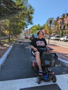
Planning for the Tremont Street Corridor redesign began in 2018, and as of 2023 now provides parking protected bike infrastructure and safer pedestrian crossings, including hardened turns into crosswalks.
Once the safe mobility lane was in place, South End residents like Antonia Sanchez (pictured at left) began to use it to travel in the neighborhood.